Tuesday, October 30, 2007

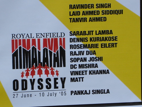
Himalayan Odyssey - III - Sarchu

We are on the forth day. On the road less travelled and left for the hard riders. Starting from Keylong our next destination will be Sarchu. We got a briefing from the captain that the road is going to be worse and bit more dangerous. Also, we need to do our days journey quick as flash floods can block our way if we take too long. (Morning hours will have less sun and therefore less power (means water) on the road crossing streams. We were also briefed on 'Barlachala Pass' on the way, which is third highest or so (Its one of the toughest anyway, looking back). Its higher than Rohtang and people are expected to have headache and other mountain sicknesses.

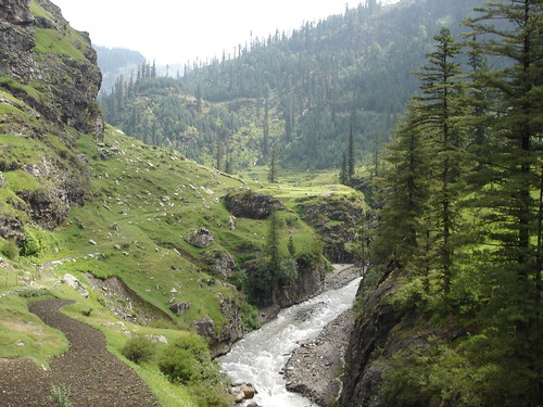
We had possibly best part of the trip in this stretch. The scenery was beautiful and its all here for you too see...

DSC00123

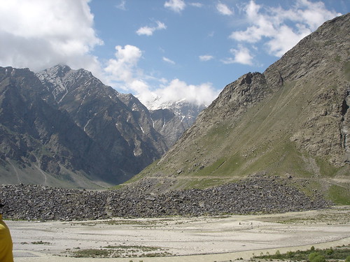
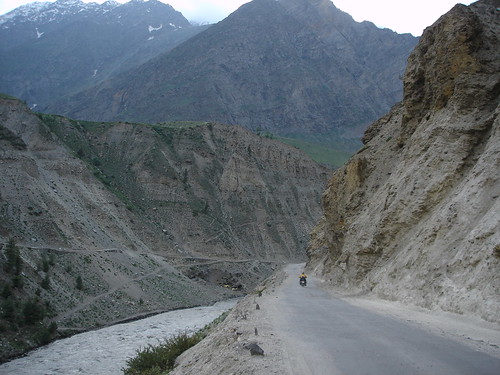
1. Somewhere on our way to Darcha (Started from Keylong). I remember that I did some of the most risky riding in this stretch. Faster than rest of the group, I along with couple of other people touched Darcha in the first 1 hour or something. Got frenzy or something.


WishYouWereThere


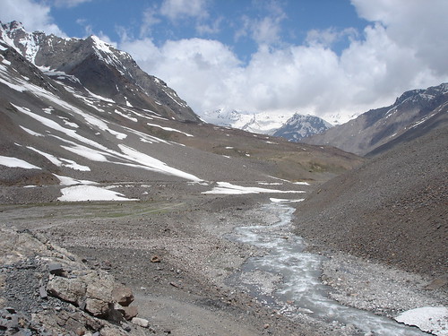
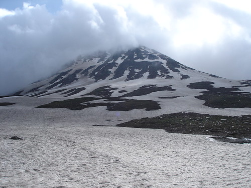
2. We are closing Barlachala Pass. Barlacha La connects Spiti district in HP to Ladakh district in J&K. Barlacha La also forms the source of two rivers Chandra & Bhaga which will form Chandrabhaga (Chenab) river later on. Both originate from lakes on (Chandra taal & Surya Taal) on Barlachala. I am not too sure which one I am seeing (Surya Taal or Chandra Taal), we saw frozen lake on the way and it was probably the most beautiful view I had on the expedition.


DSC00149

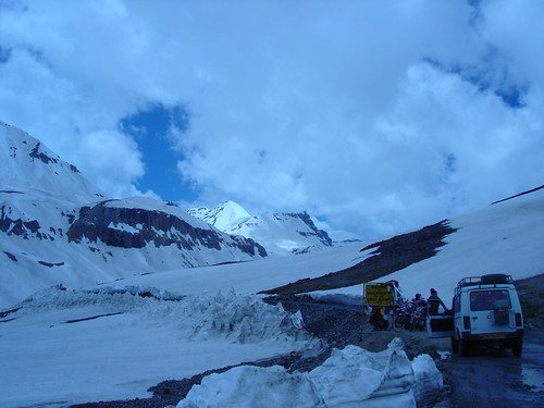
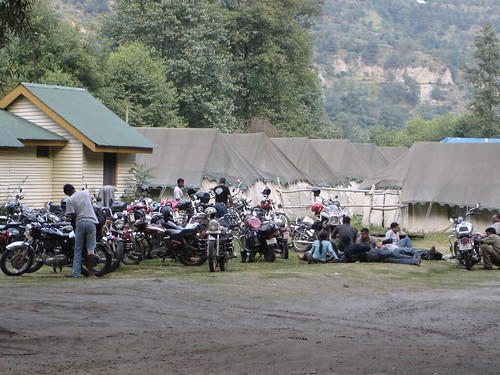
3. We are on top most point on Barlacha La (5045m). Some 1 Km higher than Rohtang Pass. One of the riders taking a respite from the strenous ride. He has vomited and crew is waiting in his support. I think I made a quick move as I myself was suffering from that extreme conditions.

On our way back we crossed Balacha La some 7am in the morning. It was the toughest ride we had with wheels sliding over the ice on the road. The weather had changed altogether. I think on that stretch I fell something like 10 times trying to stop the bike, losing balance on the ice flakes (and most bikers too, we were counting how many times each one did at the end of the day).


DSC00174

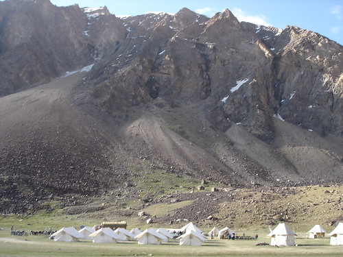
4. We reached our destination for the day. Sarchu. Its one of the important military posts. We had our tent ready out there. In the night it was to be so much cold that nothing helped (all the blankets and stuff like that proved so useless). Add to that the nasty headache and vomiting like feeling. We were just getting used to the mountain conditions. But I think we started feeling how Himalayas are like. Its a barren land. Its a desert of snow, rocks and mud. Rarely anything grow there. But it was a beauty we were all coming to terms with. Yeah it just mesmerises you and you take a while to grasp it (I dont know how to explain it).


TillEyesRechThere

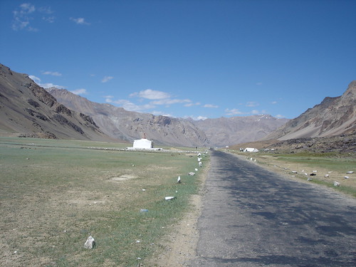
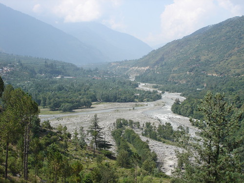
5. The plains of Sarchu looked so different from the route we had last day. We were to start from here. Sarchu is the last town on the HP side. We will cross from here to J&K. That makes this a favorite spot for tent makers.

Next would be our trip to Debring...one more stop before reaching Leh.

Monday, October 22, 2007

Himalayan Odyssey - Keylong - II

Continuing from the last post. Another day we are in Keylong. Just to get an idea of the trip, I am posting the Royal Enfield map here again.

To reach Keylong from Manali, we need to cross the Rohtang Pass. Its probably the most crowded owing to the tourists. To your surprise you will find traffic jams happening at the top of the hill. In those narrow winding roads, these traffic jams can take hours to clear off. You will wonder why on earth I wanted to do this holiday away from the city rush. Only thing I can say is that the snow out there and the view out there are truly rewarding for a people from planes.

DSC00070

1. We are climbing uphill, Rohtang Pass. Long stretches of the highway you will find that the road is almost non-existent. And consider that there is heavy rush of the tourists in the season. Look at a Maruti 800 trying to cross on of the uphill stream which can get more powerful as the day pass by. This is about 9-10 am. We trying to cross Rohtang by noon, to reach our destination safely by 3-4 pm.

DSC00078

2. So we are close, but too far. A heavy traffic jam formed some 3km from the Rohtang Pass hill top. Its some 3-4 degree Celsius and the place smell petrol and diesel. We stopped there waiting it clear off for about 1 hour, all the while trying to save our self from the snow wave. There is no food available and wait like for things to clear off is painful. You can see my fellow bikers parking along side. The traffic is because of the tourists as well as the trucks with heavy supplies taking place towards the army stations and Leh (with fuel and other essential commodities).

DSC00083

3. Yeah, we are finally at the Rohtang Hill top. Where snow meets the clouds.This was first of our hurdles, but for none of us knew that. So we had 'hurray' of success and taste of first achievement. We felt bit of oxygen deficiency, but that was OK. So now we take the road down.

DSC00113

4. Riding down we reach, Koksar on the way to Keylong. Its a great route with ravenous on sides. Keylong is till where a normal tourist would venture (sort of 120km from Manali and one can stay in Keylong peacefully). Beyond that its a long stretch of 400km where you wont find any kind of vegetation. As far as I can remember you will find a petrol pump near Keylong and then none for another 300km or so. Keylong is a beautiful valley where we reached by end of day 3 (29 Jun 2005).

Saturday, October 20, 2007

Himalayan Odyssey - Manali - I

Yeah..some old photographs again. From my bike trip to Leh in Ladakh. Some 2500km long trip which took more than 15 days. Probably one of the most strenuous trips I have been to. Its been a long cherished dream to be up on the mountains. But to do it in bike was something more than I could have asked for.

The route touches 5 Indian states and number of major national high ways. Delhi, Haryana, Punjab, Himachal Pradesh & Jammu & Kashmir. It takes you close to 50km to the India-China border in the north east of Jammu & Kashmir. The route is open only from May to August (Given the low temperature the snow melts only in that season). This also happens to be the season when lot supplies like fuel & other material for the civil & army uses get transported.


I was part of a larger convoy of 40 bikers all convened together by Royal Enfield Ltd (manufacturers of 350 & 500 CC bikes in India, the model itself is a classic from 1950, known as 'bullets'). Please visit Royal Enfield Himalayan Odyssey for more information. I was part of the 2005 expedition. There were similar events conducted in 2006 & 2007. May be you would like to book yourself for 2008 !!...

By the end of second day we reach Manali (28 June 2005). Photographs are from Manali.


DSC00058
1. A beautiful ravine ahead of Manali, on the way to Rohtang Pass (3979 m). I think at that level the place resembles our imagination of paradise. Manali itself is a great tourist spot. People do one day excursions to Rohtang, to see how it is like to climb the breathtaking heights. For us it was all beginning of our hardships.


DSC00002

2. The expedition banner at National Stadium in New Delhi (near India Gate). A souvenir for myself, my name along with 40 other participants at the flag off ceremony. The group included 2 foreign nationals and 3 women.
DSC00051

3. Our camping site at Manali. All bikes parked after days toil on the road.


DSC00036

4. Beautiful Kullu valley in Manali. You are seeing Beas river stretching along. Manali is honeymooner's paradise too.
I will post other photos in the coming posts..

Monday, October 15, 2007

Varanasi - Older than Civilisation


From my trip to Varanasi, happened in 2004 October. Yes, some 3 years ago. Its been like a destiny of sorts, a journey to Varanasi, the holiest, the timeless. A culmination of ones enquiry, may be.

There are so many things one can write about Varanasi - the ghats, the Ganges, the confluences of rivers, holy rituals, musicians, history, temples, food, festivals, rikshaws, handicrafts, benares sarees, the rajas, their mahals, the university and so on...And to some deeply involving subjects like - the liberation from ones sins, liberation from cycles of life, the meaning of death....

I will just confine myself to the these three photographs from Varanasi.

1. At Dasashwamedha Ghat - There are some 90 ghats along the river bank at Varanasi in a stretch of some 6kms. This ghat is the holiest of all, because of the 10 simlutaneous horse sacrifices conducted by Lord Brahma (Creator God in the trinity). A bath in the Dasashwamedh Ghat has become the quintessence of any pilgrimage to this holy city. We are seeing hundreds of devotees taking the holy dip early morning. Hundreds of pilgrims are practicing yoga, standing in the middle of the water and worshipping the rising sun, or meditating. The barges and boats are afloat on the river.

2. The ghatias (priests), bathed, dressed, and adorned with vibuthi (ash) marks on their foreheads, is leading / guiding the devotees on the rituals.

3. Harishchandra Ghat - This ghat is one of the two burning ghats in Varanasi. The smell and feel of death hang heavy in the air. The funeral fire never extinguished for time eternal. Its believed that one will achieve a break from the reincarnational cycle of birth, death and rebirth if they are cremated on a wood fire here when they die, their ashes scattered in the Ganges.

Saturday, October 06, 2007

Shekhawati - Open Art Gallery of Rajasthan


Photos from our recent trip to Shekhawati in Rajasthan. The region is dotted with towns and villages with painted Havelis. These Havelis are mansions belonging to Marwaris, a merchant community belonging to Marwar in Rajasthan. The region of Shekhawati had several caravan trade routes which made it an ideal spot for the merchants. The region prospered untill early 19th century. Then, as Bombay and Calcutta emerged as major industrial and trading centers, Marwaris migrated to those cities. But they didnt leave their homes deserted. Their success in the new found venues reflected back in homeland in the form of elaborate Havelis. These Havelis were further decorated with frescos as a display of their wealth and stature.

Most Havelis we see today in Shekhawati belongs to the period of 1850s to 1930s. Many of the major industrial houses in India has their roots in these Marwari towns, such as Birlas, Singhanias, Ruias...

We didnt explore much in the region. Its supposed to be some 6-8 must visit towns and the Havelis in those locations. We stayed in one of the major towns, Mandawa, some 20km from Jhunjunu. There we had the luxury of staying in one of those havelis 'Mandawa Haveli' now turned to be a hotel.

On the photographs,

1. On our way to Mandawa, there was this beautiful scene with some 2 dozens parrots perched in one of the trees. Captured a close shot having three of them.
2. Woman near one of the Havelis. She was okay being photographed, provided we pay her.
3. A sample fresco for you. Very few colors - indigo, sandstone red, vegetable green, grey etc. Frescoes in these Havelis are primarily themed on the mythological narrations....you will also find contemporary elements of the age like ships, cruises, guns, military, hourse carriage etc
4. Haveli we stayed, lit in the night. It was a great stay and good food there..